
Subject: Climatology Topic: Introduction Presented
BR
Published · 9 slides · 0 views
1 / 1

Description
Subject: Climatology Topic: Introduction Presented by: Hiba Gul CLIMATOLOGY study for building design. Bhaskaracharya calculated the time taken by the earth to orbit the sun hundreds of years before the astronomers; The Smart. Time taken by
Related Topics
Share
Embed code
Download this presentation From Below
"Subject: Climatology Topic: Introduction Presented" is the property of its rightful owner. Permission is granted to download and print the materials on this website for personal, non-commercial use only, and to display it on your personal computer provided you do not modify the materials and that you retain all copyright notices contained in the materials. By downloading content from our website, you accept the terms of this agreement.
Presentation Transcript
01
Subject: Climatology
Topic: Introduction
Presented by: Hiba Gul<br>
Topic: Introduction
Presented by: Hiba Gul<br>
02
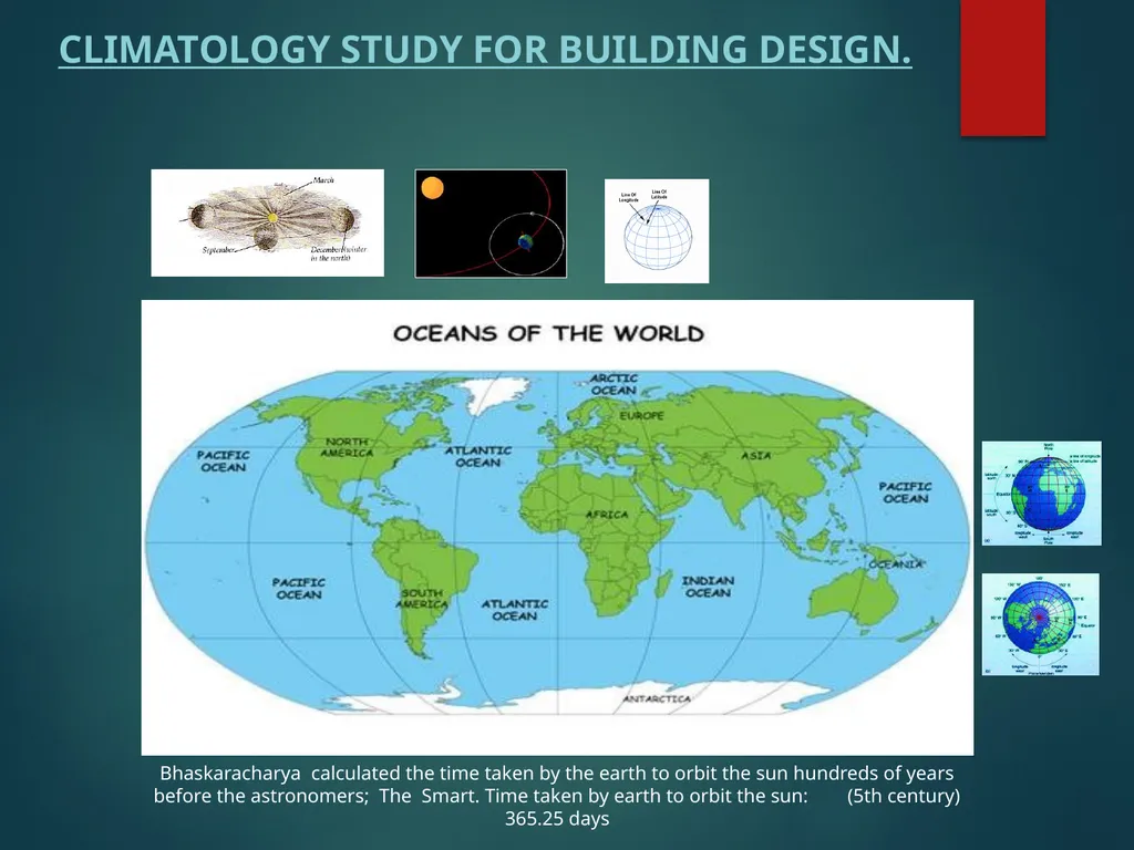
CLIMATOLOGY study for building design. Bhaskaracharya calculated the time taken by the earth to orbit the sun hundreds of years before the astronomers; The Smart. Time taken by earth to orbit the sun: (5th century) 365.25 days<br>
03
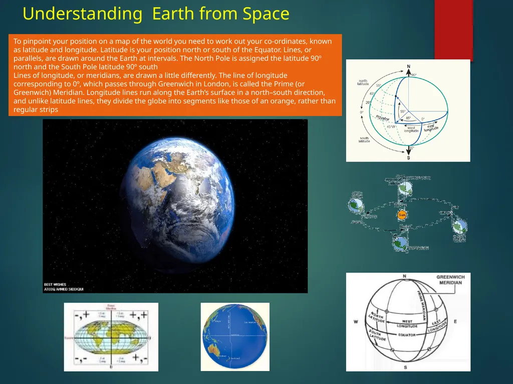
Understanding Earth from Space To pinpoint your position on a map of the world you need to work out your co-ordinates, known as latitude and longitude. Latitude is your position north or south of the Equator. Lines, or parallels, are drawn around the Earth at intervals. The North Pole is assigned the latitude 90º north and the South Pole latitude 90º south
Lines of longitude, or meridians, are drawn a little differently. The line of longitude corresponding to 0º, which passes through Greenwich in London, is called the Prime (or Greenwich) Meridian. Longitude lines run along the Earth’s surface in a north–south direction, and unlike latitude lines, they divide the globe into segments like those of an orange, rather than regular strips<br>
Lines of longitude, or meridians, are drawn a little differently. The line of longitude corresponding to 0º, which passes through Greenwich in London, is called the Prime (or Greenwich) Meridian. Longitude lines run along the Earth’s surface in a north–south direction, and unlike latitude lines, they divide the globe into segments like those of an orange, rather than regular strips<br>
04
CLIMATOLOGY- CONTENTS OF SYLLABUS Objective:
To develop the knowledge required for understanding the influence of climate on architecture.
Outline:
Introduction – Elements of climate, measurement and representations of climatic data. Classifications of tropical climates, Major climatic zones of India.
Thermal comfort: Effect of climatic elements on thermal comfort environment. Body’s heat exchange with surrounding environment. Thermal comfort indices viz., Effective temperature, bio-climatic chart etc., Kata-thermometer and globe thermometer.
Thermal performance of building elements: effect of thermo-physical properties of building materials and elements on indoor thermal environment. Thermal properties. Conductivity, resistivity, diffusivity, thermal capacity and time lag and ‘U’ value. Construction techniques for improving thermal performance of walls and roofs. Natural ventilation: Functions of natural ventilation, Design considerations, effects of openings and external features on internal air flow.
Site Climate: Effect of landscape elements on site/micro climate.
Day Lighting: Advantages and limitations, Day light factor, components of Day light factor, design considerations.
Shading devices – Sun-path diagram, use of solar charts in climatic design. Types of shading devices. Procedure of designing shading devices.
Design considerations for buildings in tropical climates with special reference to hot-dry, warm-humid and composite climates
References:
1) “Manual of Tropical Housing & Buildings (Part-II)” by Koenigsberger
2) “Housing, Climate and Comfort” by Martin Evans
3) “Buildings in the tropics” by Maxwell Fry
4) Climate Responsive Architecture “by Arvind Kishan, Baker & Szokolay”.<br>
To develop the knowledge required for understanding the influence of climate on architecture.
Outline:
Introduction – Elements of climate, measurement and representations of climatic data. Classifications of tropical climates, Major climatic zones of India.
Thermal comfort: Effect of climatic elements on thermal comfort environment. Body’s heat exchange with surrounding environment. Thermal comfort indices viz., Effective temperature, bio-climatic chart etc., Kata-thermometer and globe thermometer.
Thermal performance of building elements: effect of thermo-physical properties of building materials and elements on indoor thermal environment. Thermal properties. Conductivity, resistivity, diffusivity, thermal capacity and time lag and ‘U’ value. Construction techniques for improving thermal performance of walls and roofs. Natural ventilation: Functions of natural ventilation, Design considerations, effects of openings and external features on internal air flow.
Site Climate: Effect of landscape elements on site/micro climate.
Day Lighting: Advantages and limitations, Day light factor, components of Day light factor, design considerations.
Shading devices – Sun-path diagram, use of solar charts in climatic design. Types of shading devices. Procedure of designing shading devices.
Design considerations for buildings in tropical climates with special reference to hot-dry, warm-humid and composite climates
References:
1) “Manual of Tropical Housing & Buildings (Part-II)” by Koenigsberger
2) “Housing, Climate and Comfort” by Martin Evans
3) “Buildings in the tropics” by Maxwell Fry
4) Climate Responsive Architecture “by Arvind Kishan, Baker & Szokolay”.<br>
05
Definitions Weather; It’s the momentary state of environment at a certain location
Climate: The weather in some location averaged over some long period of time
Atmosphere: A particular environment or surrounding influence / The mass of air surrounding the Earth
Space ; Any location outside the Earth's atmosphere
Zenith: The point above the observer head, the imaginary sphere against which celestial bodies appear.
Altitude; Angular distance above the horizon (especially of a celestial object)
Latitude: An imaginary line around the Earth parallel to the equator
Longitude; The angular distance between a point on any meridian and the prime meridian at Greenwich
Earth; The 3rd planet from the sun; the planet we live on in global form & it moves around the sun in elliptical orbit“
Azimuth; the angle between the vertical plane containing it and the plane of the meridian
Meridian; An imaginary great circle on the surface of the earth passing through the north and south poles at right angles to the equator
Equinox: when the sun crosses the plane of the earth's equator during 2 times of the year
Equator; An imaginary line around the Earth forming the great circle that is equidistant from the north and south poles, A circle dividing a sphere into two equal and symmetrical parts
Ocean; A large body of water constituting a principal part of the hydrosphere
Topography ; Precise detailed study of the surface features of a region
Solar radiation; Radiation from sun
Cyclone; A violent rotating windstorm with a low pressure center; circling counterclockwise in the northern hemisphere and clockwise in the southern
Wind; Air moving from an area of high pressure to an area of low pressure
Breeze; A slight & pleasing wind (usually refreshing) it’s a low pressure wind condition.
Storm; A violent weather condition with winds 64-72 knots and precipitation and thunder and lightning
Precipitation; The water in any form falling to earth at a specific place (rain, snow, hail, sleet or mist)
Solastice; Either of the two times of the year when the sun path is at its greatest distance from the equator
Albedo; The ratio of reflected to incident light
Bathymetry; Measuring the depths of the oceans
Relative humidity ; The ratio of the amount of water in the air at a give temperature to the maximum amount it could hold at that temperature; expressed as a percentage
R Value; A measure of thermal resistance used in building and construction, with larger values corresponding to better insulation and less heat loss; it is the inverse of the U value (U-value is the inverse of R-value. U=1/R R-value is the standard way of describing how effective an insulation is ) it is easier to explain to consumers that R-19 insulation is better than R-11 rather than telling them U=0.05 insulation is better than U=0.09 The R-value of a structure made of layers of different materials can be estimated by adding the R-values of the layers. The R-value of a layer can be estimated by multiplying its thickness in inches by the R-value per inch.
U Value :A measure of how well a building element transfers heat, with smaller values corresponding to better insulation and hence less heat loss; it is the rate of energy loss per unit area per degree difference in temperature, and is equal to the inverse of the R value "a solid brick wall has a U value of about 2, similar to double glazing; well-insulated modern buildings should have walls with a U value less than 0.3“
Gale : A strong wind moving 45-90 knots; force 7 to 10 on Beaufort scale
Knot mile ; A unit of length used in navigation; exactly 1,852 meters; historically based on the distance spanned by one minute of arc in latitude<br>
Climate: The weather in some location averaged over some long period of time
Atmosphere: A particular environment or surrounding influence / The mass of air surrounding the Earth
Space ; Any location outside the Earth's atmosphere
Zenith: The point above the observer head, the imaginary sphere against which celestial bodies appear.
Altitude; Angular distance above the horizon (especially of a celestial object)
Latitude: An imaginary line around the Earth parallel to the equator
Longitude; The angular distance between a point on any meridian and the prime meridian at Greenwich
Earth; The 3rd planet from the sun; the planet we live on in global form & it moves around the sun in elliptical orbit“
Azimuth; the angle between the vertical plane containing it and the plane of the meridian
Meridian; An imaginary great circle on the surface of the earth passing through the north and south poles at right angles to the equator
Equinox: when the sun crosses the plane of the earth's equator during 2 times of the year
Equator; An imaginary line around the Earth forming the great circle that is equidistant from the north and south poles, A circle dividing a sphere into two equal and symmetrical parts
Ocean; A large body of water constituting a principal part of the hydrosphere
Topography ; Precise detailed study of the surface features of a region
Solar radiation; Radiation from sun
Cyclone; A violent rotating windstorm with a low pressure center; circling counterclockwise in the northern hemisphere and clockwise in the southern
Wind; Air moving from an area of high pressure to an area of low pressure
Breeze; A slight & pleasing wind (usually refreshing) it’s a low pressure wind condition.
Storm; A violent weather condition with winds 64-72 knots and precipitation and thunder and lightning
Precipitation; The water in any form falling to earth at a specific place (rain, snow, hail, sleet or mist)
Solastice; Either of the two times of the year when the sun path is at its greatest distance from the equator
Albedo; The ratio of reflected to incident light
Bathymetry; Measuring the depths of the oceans
Relative humidity ; The ratio of the amount of water in the air at a give temperature to the maximum amount it could hold at that temperature; expressed as a percentage
R Value; A measure of thermal resistance used in building and construction, with larger values corresponding to better insulation and less heat loss; it is the inverse of the U value (U-value is the inverse of R-value. U=1/R R-value is the standard way of describing how effective an insulation is ) it is easier to explain to consumers that R-19 insulation is better than R-11 rather than telling them U=0.05 insulation is better than U=0.09 The R-value of a structure made of layers of different materials can be estimated by adding the R-values of the layers. The R-value of a layer can be estimated by multiplying its thickness in inches by the R-value per inch.
U Value :A measure of how well a building element transfers heat, with smaller values corresponding to better insulation and hence less heat loss; it is the rate of energy loss per unit area per degree difference in temperature, and is equal to the inverse of the R value "a solid brick wall has a U value of about 2, similar to double glazing; well-insulated modern buildings should have walls with a U value less than 0.3“
Gale : A strong wind moving 45-90 knots; force 7 to 10 on Beaufort scale
Knot mile ; A unit of length used in navigation; exactly 1,852 meters; historically based on the distance spanned by one minute of arc in latitude<br>
06
Introduction of climate The root of all weather is the Sun, which heats the Earth. The heating is uneven, because of night and day, because different surfaces (such as rocks and trees) absorb
and reflect sunlight in different amounts, and because sunlight hits the equator more directly than the poles. Uneven heat creates pressure differences, and
Wind flows between areas of high and low pressure High and Low Pressure Because the Earth is warmer at the equator than at the poles, major differences in
pressure occur. Air moves north and south to try to equalize the pressure difference created by the temperature difference. The Earth rotates under this air, which
deflects its direction
Every one knows that its warmer in summer & colder in winter, why is that? The main factor is temperature due to the position of the earth in its elliptical orbit
around the sun, the 23 .5 degree tilt of the earth’s axis of rotation which gives rise to seasons in various places and the path of the sun in the sky over the course of
the day etc,. The rotation of the earth on its axis gives rise to Day and night periods and because of the tilt the length of day & night times keeps varying at different
places on earth. If there was no tilt of earth then we would have had equal day & equal night periods throughout the year. The path of the sun on earth changes
after every 6 months for the Northern & Southern hemispheres.
The polar climates have unbearable cold conditions for normal human existence and they have conditions of continuous day or darkness for almost 6 months. The sun daily rotates towards the east & Solar radiation has a lower intensity in polar regions because it travels a longer distance through the atmosphere, and is spread across a larger surface area. The sun shines 24 hours in the summer, and barely ever shines at all in the winter EARLIER BUILDING CONSTRUCTION PRACTICES
Not too long ago, building practices were almost entirely a cultural process, based on tradition. Building styles were developed over time to suit the local climate and building techniques made use of available, often local, building materials. Since World War II many countries have established and set standards of construction for safety.
Weather - related events such as extreme cold, extreme heat, extreme wind, heavy snow conditions effect the efficiency, running costs of buildings and their failures. So there is good reason for using climate services to define building standards and performance. In different areas of the world, thermal comfort needs may vary based on climate. In China there are hot humid summers and cold winters causing a need for efficient thermal comfort. Energy conservation in relation to thermal comfort has become a large issue in China in the last several decades due to rapid economic and population growth. Researchers are now looking into ways to heat and cool buildings in China for lower costs and also with less harm to the environment.
In tropical areas of Brazil, urbanization is causing a phenomenon called urban heat islands (UHI). These are urban areas, which have risen over the thermal comfort limits due to a large influx of people and only drop within the comfortable range during the rainy season. Urban Heat Islands can occur over any urban city or built up area with the correct conditions. Urban Heat Islands are caused by urban areas with few trees and vegetation to block solar radiation or carry out evapo-transpiration, Sun may be described as the engine of climate as he supplies large amount of energy to Earth<br>
and reflect sunlight in different amounts, and because sunlight hits the equator more directly than the poles. Uneven heat creates pressure differences, and
Wind flows between areas of high and low pressure High and Low Pressure Because the Earth is warmer at the equator than at the poles, major differences in
pressure occur. Air moves north and south to try to equalize the pressure difference created by the temperature difference. The Earth rotates under this air, which
deflects its direction
Every one knows that its warmer in summer & colder in winter, why is that? The main factor is temperature due to the position of the earth in its elliptical orbit
around the sun, the 23 .5 degree tilt of the earth’s axis of rotation which gives rise to seasons in various places and the path of the sun in the sky over the course of
the day etc,. The rotation of the earth on its axis gives rise to Day and night periods and because of the tilt the length of day & night times keeps varying at different
places on earth. If there was no tilt of earth then we would have had equal day & equal night periods throughout the year. The path of the sun on earth changes
after every 6 months for the Northern & Southern hemispheres.
The polar climates have unbearable cold conditions for normal human existence and they have conditions of continuous day or darkness for almost 6 months. The sun daily rotates towards the east & Solar radiation has a lower intensity in polar regions because it travels a longer distance through the atmosphere, and is spread across a larger surface area. The sun shines 24 hours in the summer, and barely ever shines at all in the winter EARLIER BUILDING CONSTRUCTION PRACTICES
Not too long ago, building practices were almost entirely a cultural process, based on tradition. Building styles were developed over time to suit the local climate and building techniques made use of available, often local, building materials. Since World War II many countries have established and set standards of construction for safety.
Weather - related events such as extreme cold, extreme heat, extreme wind, heavy snow conditions effect the efficiency, running costs of buildings and their failures. So there is good reason for using climate services to define building standards and performance. In different areas of the world, thermal comfort needs may vary based on climate. In China there are hot humid summers and cold winters causing a need for efficient thermal comfort. Energy conservation in relation to thermal comfort has become a large issue in China in the last several decades due to rapid economic and population growth. Researchers are now looking into ways to heat and cool buildings in China for lower costs and also with less harm to the environment.
In tropical areas of Brazil, urbanization is causing a phenomenon called urban heat islands (UHI). These are urban areas, which have risen over the thermal comfort limits due to a large influx of people and only drop within the comfortable range during the rainy season. Urban Heat Islands can occur over any urban city or built up area with the correct conditions. Urban Heat Islands are caused by urban areas with few trees and vegetation to block solar radiation or carry out evapo-transpiration, Sun may be described as the engine of climate as he supplies large amount of energy to Earth<br>
07
Bangalore’s position on our globe
is at 14 degree NORTH latitude The positions of these circles of latitude (other than the Equator) are dictated by the tilt of the Earth's axis of rotation relative to the plane of its orbit. The Tropic of Cancer, also referred to as the Northern tropic, is the circle of latitude on the Earth that marks the most northerly position at which the Sun may appear directly overhead at its zenith. This event occurs once per year, at the time of the June solstice, Its Southern Hemisphere counterpart, marking the most southerly position at which the Sun may appear directly overhead, is the Tropic of Capricorn.during December<br>
is at 14 degree NORTH latitude The positions of these circles of latitude (other than the Equator) are dictated by the tilt of the Earth's axis of rotation relative to the plane of its orbit. The Tropic of Cancer, also referred to as the Northern tropic, is the circle of latitude on the Earth that marks the most northerly position at which the Sun may appear directly overhead at its zenith. This event occurs once per year, at the time of the June solstice, Its Southern Hemisphere counterpart, marking the most southerly position at which the Sun may appear directly overhead, is the Tropic of Capricorn.during December<br>
08
Weather issues Clouds are often created when two different types of air masses run into each other -- a warm air mass and a cold air mass. Typically, the warm air gets pushed up over the cold air..
High-speed winds race around the globe between four and six miles above the earth, mostly from west to east. These rivers of air are often collectively referred to as the jet stream, and they form at the boundaries of warm and cold air, Rain converts wind force to heat, by friction and Abrupt electric discharge from cloud to cloud or from cloud to earth accompanied by the emission of lightning & thunder.
Spectacular, powerful, and sometimes deadly, lightning is one of the most common weather phenomena. Satellites detect more than 3 million lightning flashes each day around the world, or an average of more than 30 flashes per second. Lightning kills more people than tornadoes, hurricanes, or any other kind of bad weather except floods. But because lightning usually kills people one at a time, it tends to be underrated as a hazard. The best protection against lightning is to stay indoors during a thunderstorm. But stay away from the telephone; about 1% of people killed by lightning were talking on the phone at the time. If you cannot reach a building, a car offers excellent protection.
Hurricane, cyclone, typhoon, these are all describing the same thing, a powerful wind and rain storm that can tear apart houses and flood entire cities. Even though the name is different, they have the same make up, need the same conditions for formation, and cause the same damaging side effects.
What Causes a Hurricane?
Relatively simple in composition, what we are going to refer to as a hurricane is made up of a low-pressure center called ‘the eye’ and a spiral arrangement of thunderstorms extending from its center. To make this particular combination occur, there are several natural factors that need to be present in the environment.
First, wind conditions are only suitable from roughly latitude 5° and 20° North and South of the Equator, where the Coriolis Effect, the force which causes rotary motion in winds, is strong enough to cause rotation. Typically, the conditions are not right from 0° to 5° North and South.
Second, you need the right wind conditions, meaning the temperature in the atmosphere must at greatest difference from the sea surface temperature.
Third, the water needs to be warm, at least 79.7 degrees Faren height at a depth of 160 feet. Finally there needs to be a disturbance in the atmosphere. When these factors are presents, a storm is capable of forming.<br>
High-speed winds race around the globe between four and six miles above the earth, mostly from west to east. These rivers of air are often collectively referred to as the jet stream, and they form at the boundaries of warm and cold air, Rain converts wind force to heat, by friction and Abrupt electric discharge from cloud to cloud or from cloud to earth accompanied by the emission of lightning & thunder.
Spectacular, powerful, and sometimes deadly, lightning is one of the most common weather phenomena. Satellites detect more than 3 million lightning flashes each day around the world, or an average of more than 30 flashes per second. Lightning kills more people than tornadoes, hurricanes, or any other kind of bad weather except floods. But because lightning usually kills people one at a time, it tends to be underrated as a hazard. The best protection against lightning is to stay indoors during a thunderstorm. But stay away from the telephone; about 1% of people killed by lightning were talking on the phone at the time. If you cannot reach a building, a car offers excellent protection.
Hurricane, cyclone, typhoon, these are all describing the same thing, a powerful wind and rain storm that can tear apart houses and flood entire cities. Even though the name is different, they have the same make up, need the same conditions for formation, and cause the same damaging side effects.
What Causes a Hurricane?
Relatively simple in composition, what we are going to refer to as a hurricane is made up of a low-pressure center called ‘the eye’ and a spiral arrangement of thunderstorms extending from its center. To make this particular combination occur, there are several natural factors that need to be present in the environment.
First, wind conditions are only suitable from roughly latitude 5° and 20° North and South of the Equator, where the Coriolis Effect, the force which causes rotary motion in winds, is strong enough to cause rotation. Typically, the conditions are not right from 0° to 5° North and South.
Second, you need the right wind conditions, meaning the temperature in the atmosphere must at greatest difference from the sea surface temperature.
Third, the water needs to be warm, at least 79.7 degrees Faren height at a depth of 160 feet. Finally there needs to be a disturbance in the atmosphere. When these factors are presents, a storm is capable of forming.<br>
09
Hundreds of millions of people in urban areas across the world will be affected by climate change. The vulnerability of human settlements will increase through rising sea levels, inland floods, frequent and stronger tropical cyclones, periods of increased heat and the spread of diseases. Climate change may worsen the access to basic urban services and the quality of life in cities. Most affected are the urban poor – the slum dwellers in developing countries. UN-HABITAT's Sustainable Cities Programme help cities get the most out of their vital role in social and economic development by promoting better environmental policies and programmes, aimed at reducing pollution, and improving urban environment management
Weather - related events such as extreme cold, extreme heat, extreme wind, heavy snow conditions effect the efficiency, running costs of buildings and their failures. So there is good reason for using climate services to define building standards and performance.
.<br>