PPT-GEOGRAPHY Presentation, Graphic Organizers, & Activities
Author : alida-meadow | Published Date : 2018-11-21
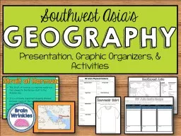
Southwest Asias GEOGRAPHY Southwest Asia I Political Features Label the following countries on the map Afghanistan Iran Iraq Israel Saudi Arabia Turkey II Physical
Presentation Embed Code
Download Presentation
Download Presentation The PPT/PDF document "GEOGRAPHY Presentation, Graphic Organize..." is the property of its rightful owner. Permission is granted to download and print the materials on this website for personal, non-commercial use only, and to display it on your personal computer provided you do not modify the materials and that you retain all copyright notices contained in the materials. By downloading content from our website, you accept the terms of this agreement.
GEOGRAPHY Presentation, Graphic Organizers, & Activities: Transcript
Download Rules Of Document
"GEOGRAPHY Presentation, Graphic Organizers, & Activities"The content belongs to its owner. You may download and print it for personal use, without modification, and keep all copyright notices. By downloading, you agree to these terms.
Related Documents


![[DOWNLOAD] - The Teacher\'s Big Book of Graphic Organizers: 100 Reproducible Organizers](https://thumbs.docslides.com/901411/download-the-teacher-s-big-book-of-graphic-organizers-100-reproducible-organizers-that-help-kids-with-reading-writing-and-the-co.jpg)
![[EPUB] - Teaching Writing Through Differentiated Instruction With Leveled Graphic Organizers:](https://thumbs.docslides.com/901726/epub-teaching-writing-through-differentiated-instruction-with-leveled-graphic-organizers-50-reproducible-leveled-organizers.jpg)