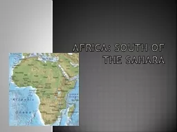
Preview African Geography Africa is a large continent surrounded by oceans and seas It is divided in two by the Sahara Desert SubSaharan Africa is the region south of the Sahara Desert Farming Herding and Trade ID: 697732
Download Presentation The PPT/PDF document "Geography of Africa 6 th Grade UBD - Uni..." is the property of its rightful owner. Permission is granted to download and print the materials on this web site for personal, non-commercial use only, and to display it on your personal computer provided you do not modify the materials and that you retain all copyright notices contained in the materials. By downloading content from our website, you accept the terms of this agreement.
Slide1
Geography of Africa
6
th Grade UBD - Unit 8 - Geography of AfricaSlide2
Preview
African Geography
-
Africa is a large continent surrounded by oceans and seas. It is divided in two by the Sahara Desert. Sub-Saharan Africa is the region south of the Sahara Desert.
Farming, Herding, and Trade
-
The lives of people in Sub-Saharan Africa were shaped by their environment. People migrating between climate zones had to adapt.Slide3
Reach Into Your Background
Predict how geography affects
patterns
of settlement and commerce? Then explain how the geographic features of an area affect its development.
( 5 minutes)Slide4
Partner Activity
Work with a neighbor and compare your answer with theirs. What things are the same and what things are different?
(3 minutes)Slide5
Key Ideas- African Geography
Africa lies between two oceans, the Atlantic and the Indian. It also is bordered by the Red Sea and the Mediterranean Sea.
Africa has four major rivers: the Nile, the Niger, the Congo, and the Zambezi. All of the rivers are navigable in places. However, near the coast, each river has a series of cataracts, or waterfalls. These keep boats from traveling from the coast to the interior.
Sub-Saharan Africa has four climate zones: desert, semiarid or Sahel, savanna (grasslands), and tropical forests
.Slide6
Key Term
Africa
-
T
he
second-largest continent in the world. It is large enough that you could put the United States, Europe, China, and most of India within its borders.Slide7
Africa's Geography
Video-
Africa's GeographySlide8
African Geography
Africa is the second-largest continent on Earth, comprising about one-fifth, or 20 percent, of the world’s total land mass.
In
2010, its population topped 1 billion; its peoples spread across 54
countries—and
several territories, or states of disputed status.Slide9
African Geography
M
ost
of
Africa lands
lie within the tropics. Despite this, Africa has diverse vegetation and climate zones as well as many unique physiographic features.
Its
landscapes range from tropical rainforest to desert and from savanna to snow-capped mountain.Slide10
Key Term
Rainforest
- A
dense
forest rich in biodiversity, found typically in tropical areas with consistently heavy rainfall.Slide11Slide12
Climate and Vegetation
Video- Climate and VegetationSlide13
The Sahel
Reading Handout- The SahelSlide14
Large Rivers
Perhaps Africa’s greatest resource throughout its
history has
been its rivers, which carry much needed water inland, vital to the growth of agriculture and civilization.Slide15
Large Rivers
Although Africa is best known as home to the Nile River, the longest river on the globe, the Niger, Congo, and Zambezi river systems, as well as many smaller rivers, have also helped shaped the land and its peoples.Slide16
African Geography
The continent is also bordered by three oceans—the Atlantic, the Indian, and the Southern—and by the Mediterranean Sea and the Red Sea. Slide17
On the Move
I
t
was from Africa that the earliest ancestors of modern humans mostly likely first walked.
The
Olduvai Gorge in northern Tanzania, part of the Great Rift Valley, has been credited as the home of the oldest stone tools and was once inhabited by human ancestors, known as
homo
habilis
and
homo erectus,
more than a million years ago.Slide18
Major Cities
Africa is also home to the great civilization of the ancient Egyptians, which emerged along the Nile River more than 5,000 years ago.
Its
greatest cities included Memphis and Thebes and, later, Alexandria. Slide19
On the Move
These waterways and landways made possible not only early human migration but also later trade and conquest.
Traffic
among the peoples of Europe, Asia, and Africa has a long tradition, especially in the north and along the eastern and western coasts of the continent.Slide20
Major Cities
The
modern capital
of Egypt is Cairo.
Cairo is
situated close to the renowned pyramids at Giza, would not be built until centuries later during Arab rule.Slide21
Key Ideas- Farming, Herding, and Trade
Climate
zones have determined how people made a living in Sub-Saharan Africa. In the forests, farmers grew yams, palm trees, and kola trees. In the savannas, farmers grew grain crops. In the semiarid and desert areas, people were nomadic herders. They moved from place to place seeking water and food for their animals.
There were different resources in each climate zone. People traded for goods they could not produce themselves. This caused trade routes to develop.Slide22
Key Term
Climate
Zone
-
A
specific area that has a specific climate. Each climate zone will have its own certain parameters. Climate zones can be tropical, dry, temperate, or polar. Slide23
On the Move
Although Egypt has long been the source of myth, legend, and even popular movie-making, other great civilizations also arose across Africa.
Among
these were the Bantu
peoples.Slide24
On the Move
T
he
Bantu peoples who spread from West Africa south and east in a series of migrations from 2000 BCE to 1000
CE.
Most of the modern-day peoples of southern and eastern Africa descend to some degree from the Bantu who branched out across the lands, forming their own ethnic groups, languages, and cultures.Slide25
Trade
I
n
West Africa, several kingdoms—Ghana, Mali, and Songhai—prospered from the trade of gold and salt.
On
the Horn of Africa, the trading city of Aksum (or Axum) flourished from the 300s through the 600s, after which it began to decline. Slide26
Trade
The waters of Africa proved valuable as a source of irrigation for agriculture, travel, and trade.
The
vast deserts of the Sahara, though largely uninhabited, nonetheless saw frequent use by nomadic herders and trade caravans. Slide27
Key Term
Desert
- An
arid
region that
it receives little precipitation. Most deserts receive an average of fewer than 10 inches of precipitation each year. Slide28
Key Term
Caravan
- A
company of traders or other
travelers
journeying together, often with a train of camels, through the desert.Slide29
The Sahara Desert
Video- The Sahara DesertSlide30
Resources
The forests of Africa, particularly along the western coast and the interior, also provided valuable sources of goods such as kola nuts, cacao, and the wood itself. Slide31
Resources
African gold once helped give rise to great trading empires, many other minerals continue to bolster the economy in Africa, even to this day—most notably diamonds.Slide32
History
The continent of Africa has had a long, complicated history rich in diverse and celebrated peoples but marked as well by tragedy. Its resources have given rise to great empires but have also attracted not only foreign trade but also foreign invasion.Slide33
History
Some conquests sought to reap raw materials; others took Africa’s peoples for the purpose of enslavement.
Today
, the many countries and territories of Africa struggle to overcome not only geographic challenges—including a scarcity of clean water sources—but also the legacy of their colonial histories and rivalries between ethnic, religious, and tribal groups.Slide34
Independent Activity
What has been the “muddiest” point so far in this lesson? That is, what topic remains the least clear to you?
(
4 minutes)Slide35
Partner Activity
Work with a neighbor and compare your muddiest point with theirs. Compare what things are the same and what things are different? (3 minutes)