/
 Geography of South Asia Physical  Geography of South Asia Physical

Geography of South Asia Physical - PowerPoint Presentation

danika-pritchard
danika-pritchard . @danika-pritchard
Follow
342 views
Uploaded On 2020-04-03

Geography of South Asia Physical - PPT Presentation

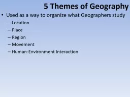
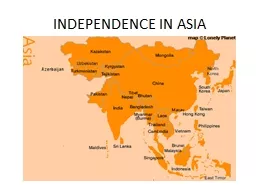
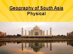
The Indian Subcontinent India Pakistan Bangladesh Bhutan Nepal Sri Lankaamp the Maldives Subcontinent large landmass thats smaller than a continent called Indian Subcontinent because India dominates the region ID: 775031

amp india pakistan people amp india pakistan people indian bangladesh south river mountains asia subcontinent living population east education

Share:

Link:

Embed:

Download Presentation from below link

Download Presentation The PPT/PDF document " Geography of South Asia Physical" is the property of its rightful owner. Permission is granted to download and print the materials on this web site for personal, non-commercial use only, and to display it on your personal computer provided you do not modify the materials and that you retain all copyright notices contained in the materials. By downloading content from our website, you accept the terms of this agreement.


Presentation Transcript

Slide1

Geography of South AsiaPhysical

Slide2

The Indian Subcontinent

India, Pakistan, Bangladesh, Bhutan, Nepal, Sri Lanka,& the Maldives Subcontinent - large landmass that’s smaller than a continent - called Indian Subcontinent because India dominates the region

Slide3

Slide4

The Indian Subcontinent

Has 1/5 of world’s people (1/2 the size of U.S.,)Natural barriers separate subcontinent from rest of Asia - mountains form northern border, Indian Ocean surrounds rest - Arabian Sea to west, Bay of Bengal to east

Slide5

Mountains

Himalaya Mountains—1,500-mile-long system of parallel ranges - Includes world’s tallest mountain—Mt. Everest - Forms barrier between Indian subcontinent and China

Slide6

Slide7

Slide8

Mountains

Hindu Kush mountains - separates Pakistan & Afghanistan - historically blocked invasions from Central Asian tribes - Khyber Pass is one of the major land routes through the mountains Karakoram Mountains are in northeastern part of Himalayas - Includes world’s second highest peak, K2

Slide9

Khyber Pass

Slide10

Rivers

Indus River -Flows west, then south through Pakistan to Arabian Sea Brahmaputra winds east, then west, south through Bangladesh -Meets the Ganges & forms delta (flow into Bay of Bengal)

Slide11

Rivers

Feni

River

- flows from Chittagong Hills to Bay of Bengal

-floods during wet season due to monsoon rains

- Cyclones bring

storm surges

—high waters that swamp low areas

-1980s - Bangladesh built South Asia’s largest

estuary

– a broadened seaward end of a river

used large population’s unskilled workers to build dam

(abundant resource)

Slide12

Slide13

Ganges River

Best-known South Asian river (Known as Gangamai—“Mother Ganges”)Provides drinking and farming water, transportation Hindus believe that the Ganges River brings life to its people (Sacred)- pilgrims come to bathe, scatter ashes of dead

Slide14

Slide15

Slide16

Ganges River

Ganges is one of the most polluted river in world - sewage, industrial waste, & human bodies - users get stomach and intestinal diseases such as hepatitis, typhoid, & cholera 1986 - government planned sewage treatment plants & regulations - today few plants are operational, factories still dump waste - Clean up will take time, money, a change in how people see river

Slide17

Slide18

Fertile Plains

Rivers irrigate farmlands& carry rich alluvial soil - Soil is deposited on alluvial plains—rich farmlands Indo-Gangetic Plain has some of the world’s most fertile farms Heavily populated area has 3/5 of India’s people

Slide19

 Offshore Islands

Sri Lanka - Island in Indian Ocean, off India’s southeastern tip Large, tear-shaped country with lush tropical land Range of high, rugged, 8,000-foot mountains dominate center

Slide20

Slide21

Offshore Islands

Maldives - is archipelago—island group—of 1,200 small islands - Islands are atolls— - formed from a peak of a submerged volcano - only 200 islands are inhabited

Slide22

Slide23

 Natural Resources

Water

and

soil

- Provides food through farming & fishing

River systems help enrich land with alluvial soil & water

Also provide transportation & power

Slide24

Natural Resources

Rain forests produce hardwoods like sal, teak, bamboo and fragrant sandalwood -Deforestation is a severe problem (soil erosion, flooding, landslides, loss of wildlife habitats)

Slide25

Natural Resources

Minerals -Coal - India is fourth in world production of coal - also has petroleum, uranium Iron ore & mica (crystals)Pakistan & Bangladesh have natural gas resources

Slide26

 Climate Zones

Cold highland zone - Himalayas & other northern mountains Humid subtropical – Located in the foothills (Nepal, Bhutan)& Indo-Gangetic Plain Semiarid zone - West Plain & Deccan Plateau is warm with light rain

Slide27

Slide28

Climate Zones

Desert zone - Thar Desert is driest area, with 10 inches of rain annually Tropical wet zone - Sri Lanka and coasts of India, Bangladesh - Cherrapunji, India, holds rainfall record—366 inches in one month

Slide29

Monsoons and Cyclones

Monsoons—seasonal winds that affect entire region ( two seasons)Summer monsoon—blows moist from southwest, across Indian Ocean (Brings rain)Winter monsoon—blows cool from northeast, across Himalayas, to sea (drought)

Slide30

Slide31

Monsoons and Cyclones

- Bangladesh’s low coastal region swamped by high waves

Cyclone

—violent storm with fierce winds & heavy rain (hurricanes in North America)

Slide32

Slide33

Physical Review

What type of weather is associated with a winter monsoon?

What type of weather is associated with a summer monsoon?

What is an archipelago?

.What do the Himalayan Mountains form a barrier between?

What is an atoll?

What are alluvial plains?

What is a subcontinent?

What is an

abunadant

resource in Bangladesh that was used to build a dam on the

Feni

River?

What is an estuary?

What is a storm surge?

Mount Everest is located in what mountain range?

What desert is located in South Asia?

What type of landform is South Asia?

Slide34

History

Slide35

Early History

 2500 B.C. - Indian civilization began in Indus Valley 1500 B.C. - Aryans from north of Iran invaded

Slide36

 European Rule

1500s - French, Dutch, & Portuguese built cloth, & spice trades 1757 - British East India Company controlled Indian tradeRaj – 200-years of British rule in India

Slide37

European Rule

Mohandas Gandhi - Led Indian independence movement (nonviolent resistance) 1947 - India gained its independence from BritainMuslim Pakistan split from Hindu India

Slide38

Slide39

 Partition and War

 1947 - partition created Hindu India & Muslim Pakistan Hindu-Muslim violence killed one million people10 million people crossed borders: Hindus to India, Muslims to Pakistan Pakistan & India have fought wars over territory

Slide40

 Pakistan and Bangladesh

Ethnic differences led to civil war between West and East Pakistan1971 - East Pakistan won independence & became Bangladesh (Partition)

Slide41

Slide42

History Review

Who led India’s independence movement?

What is nonviolent resistance?

What was the partition of India& Pakistan in 1947?

What was Raj?

What two countries have fought several wars over the territory of Kashmir?

Where did civilization first begin in South Asia?

What country was known as East Pakistan between 1947 & 1971?

Slide43

Culture

Slide44

Languages

India has over 1000 languages and dialects

-

Hindi

is the official language

Pakistan is more diverse: five main groups, each with own language

- Punjabis,

Sindhis

,

Pathans

,

Muhajirs

,

Balochs

Majority of people in Bangladesh are Bengali

- Bengali language based on

Sanskit

,

ancient Indo-Aryan language

Slide45

Religions

-Karma - all good are rewarded and all bad deeds punishedPeople are reincarnated until they overcome all of their weaknesses and earthly desires, then they are released form the cycle of rebirth

Hinduism

– 80% of Indians are Hindu

- Believes in a system of social classes (caste system)

People must live according to his or her

dharma

or moral duty

Slide46

Religions

- Pakistan’s stricter Islamic law includes

purdah—women’s seclusion - women have no contact with men not related, wear veils in public - Bangladesh’s religious practices are less strict

Islamic

– Over 90 % of the populations of Pakistan and Bangladesh

Slide47

Religions

Buddhism

– started by Siddhartha Gautama By following his guidelines, people could enter into a state of great insight, calm, and happiness called nirvana Jainism – Believe that every living creature has a soul therefore it is a sin to kill even an insect

Slide48

Slide49

Culture Review

What religion do most Indians belong to?

Who founded the religion of Buddhism?

What is the caste system & what religion believes in it?

What is the predominate religion in Pakistan & Bangladesh?


Slide50

Living In South Asia Today 

Slide51

Daily Life

Most Indians have male-dominated arranged marriages Diet is mostly vegetarian - meat is eaten in curry dishes, but is limited by religious beliefs Sports include soccer, field hockey & cricket

Slide52

Education

Indian economy is changing & more people are working in factories,& offices Education is key to change Literacy has risen steadily since the 1950s school attendance, literacy still low In slums and rural areas

Slide53

Population Problems

South Asia must manage population growth so economies can develop

Rapid growth means many citizens lack life’s

basic necessities

- food, clothing, shelter

Slide54

Population Problems

Region has widespread poverty, illiteracy—inability to read or write - poor sanitation, health education lead to disease outbreaks Every year, to keep pace, India would have to: - build 127,000 new schools and 2.5 million new homes - create 4 million new jobs - produce 6 million more tons of food

Slide55

Slide56

Managing Population Growth

India spends nearly $1 billion a year encouraging smaller families

Programs have only limited success

- Indian women marry before age 18, start having babies early

-

Poor people view children as source of money (begging or working fields)

- children can later take care of elderly parents

- have more kids to beat high infant mortality

Education

could break cycle of poverty & raise living standards ( limited funds)

- India spends under $6 per pupil a year on education

- U.S. spends $6,320 per pupil a year

- improves females’ status with job opportunities

-better health care education could lower infant mortality rates

Slide57

Living In South Asia Today Review

What is considered the key to controlling India’s population as well improving its standard of living?

What is illiteracy?

What country in South Asia has the largest population?

Name three reasons that Indian families continue to have a large number of children?

Name three basic necessities:


Slide58

Economy

Slide59

Agriculture

Two-thirds of people farm (Subsistence Farmers) After famines of 1960s, scientists improved farming techniques& crops - Green Revolution increased crop yields for wheat & rice Pakistan & Bangladesh’s Climate hurts yields (arid & stormy) -freshwater fishing is also vital to economy

Slide60

Slide61

Industry

Cotton textiles have long been a major producer in India

- iron, steel, chemical, food industries develop after 1940s

Neither Pakistan or Bangladesh is highly industrialized

- small factories lack capital, resources, markets to expand

Both export cotton clothes

Microcredit

policy allows small loans to poor entrepreneurs

-

entrepreneurs

—people who start and build businesses

- small businesses join together to get microloans

- program raises standards of living, especially for women

Slide62

Increasing Tourism

Tourism is fastest-growing industry in Nepal- people visit capital at Kathmandu to climb Himalayas- hotels, restaurants, services grow- also hurts Nepal’s environment; trash, pollution left on mountains

Slide63

Economy Review

What is Microcredit?

What is an entrepreneur?