Explore
Featured
Recent
Articles
Topics
Login
Upload
Featured
Recent
Articles
Topics
Login
Upload
Search Results for 'Usgs-Lidar'
Usgs-Lidar published presentations and documents on DocSlides.
High Accuracy Helicopter Lidar & Mapping
by natalia-silvester
Jeffrey B. Stroub, CP,RLS,PPS,SP. Vice President ...
LiDAR Overview What LiDAR is . . .
by yoshiko-marsland
. . . . Li. ght . D. etection . A. nd . R. angin...
LiDAR Enhanced Forest Inventory in British Columbia
by chaptoe
Challenges and Opportunities. By. Xiaoping Yuan. F...
Overview of upcoming lidar wake experiments at DTU
by clustik
Elliot Simon. DTU Wind Energy (. RISØ. ). ellsim@...
Characterizing CA Spotted Owl Habitat with Lidar
by verticalbikers
Jonathan Kane. Malcolm North. Van Kane. Greg Asner...
FPGA Programming for Real Time Analysis of Lidar
by lindy-dunigan
Systems. Dr. Sameh Abdelazim. Assistant Professor...
Community-wide urban stormwater planning utilizing LiDAR, the WinSLAMM model and GIS
by cheryl-pisano
Dan Murphy. Rebecca Gronewold. UNI GeoTREE Center...
Estimating Rooftop Solar Electricity Potential in Seattle from LiDAR Data
by pamella-moone
Ryan M. Liddell. Faculty advisor: Dr. Joe Bishop....
Minnesota LiDAR: Minnesota
by danika-pritchard
LiDAR. Wednesday , November 4. th . 2015, 1:00 pm...
AIMS use of Lidar Primary uses
by lois-ondreau
Contour creation. DTM/DSM generation. Ortho photo...
LiDAR Analysis of Mixed-Species, Multi-Cohort Stands
by tatyana-admore
Dr. John A. Kershaw, Jr.. Western . M. ensuration...
LiDAR Cave Mapper
by alexa-scheidler
FAMU-FSU College of Engineering. ME & ECE Sen...
Using LiDAR Data to Automatically Delineate Sinkholes in So
by natalia-silvester
Nate Green and Jacob Hartle. Forest and Natural R...
LiDAR Cave Mapper
by calandra-battersby
FAMU-FSU College of Engineering. ME & ECE Sen...
THE LIGHT FANTASTIC USING AIRBORNE LIDAR IN ARCHAEOLOGICAL SURVEY S
by cheryl-pisano
Crutchley Aerial Survey Investigation Research D...
BSHC LIDAR
by faustina-dinatale
S. eminar. SMA . e. xperiences. . from and . fut...
LiDAR
by alexa-scheidler
Compressor 1.1. Compression. Lossless. 25. % or s...
Raster lidar data visualizations for
by tatiana-dople
interpretation. . of. . microrelief. . structu...
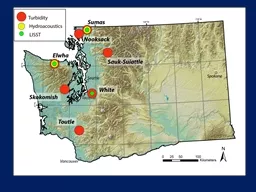
Hydrologic Measurement
by myesha-ticknor
Precipitation. Evaporation. Streamflow. Channel ....
USGS Next Generation Water Observing System Program
by valerie
NASA NOS Workshop Bethesda, MD . 02/25-26/2020 . J...
USGS Science for a Changing Everglades
by bikersnomercy
Vic Engel. Wetland and Aquatic Research . Center. ...
2/21/2013 2013 USGS NSHMP CA Workshop II
by gristlydell
1. UCERF3.2: . Hazard Implications. Hazard . compa...
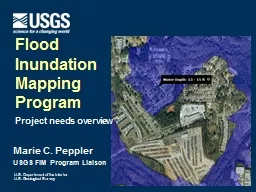
Marie C. Peppler USGS FIM Program Liaison
by mentegor
Flood . Inundation . Mapping. Program. Project nee...
USGS Training and Special Projects
by alida-meadow
Training: 3 Annual technical training courses hel...
Marie C. Peppler USGS FIM
by liane-varnes
Coordinator. Flood . Inundation . Mapping. Progra...
USGS ACTIVITY:
by pasty-toler
Estimating . . suspended-sediment. load continuo...
Welcome to the USGS Webinar:
by liane-varnes
New Science and Online Management Tools to Help G...
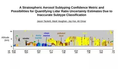
A Stratospheric Aerosol Subtyping Confidence Metric and Possibilities for Quantifying Lidar Ratio U
by barbara
Jason Tackett, Mark Vaughan, Jay Kar, Ali Omar. Al...
Elevate Accuracy and Efficiency with Lidar Surveys: Precision Mapping and Data Insights
by garudsurvey
Lidar surveys are a game-changer for precision map...
USDA Forest Service, Remote Sensing Applications Center,
by queenie
FSWeb: http://fsweb.rsac.fs.fed.us. WWW: http://ww...
The Status of
by jovita
Vegetation Lidar MOLITadashi Imaia Rei Mitsuhashia...
Use of Solar Induced Fluorescence and LIDAR to Assess Vegetation
by barbara
Change and VulnerabilityMarch 16 25 2021Part 2 Que...
Masato Hayashi Tadashi Imai
by kimberly
Daisuke SakaizawaJumpeiMurookaRei Mitsuhashi Toshi...
Press Release
by beatrice
August 2 7 , 2020 LYON, France LiDAR is facing he...
Atmospheric Monitoring
by sylvia
in . the. TA experiment. Takayuki . Tomida. . an...
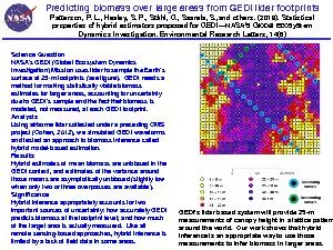
Predicting biomass over large areas from GEDI lidar footprints ...
by mila-milly
Patterson, P. L., Healey, S. P., St
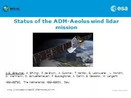
Status of t he ADM-Aeolus wind
by doggcandy
lidar. . mission. A.G. . Straume. 1. , . A. . Elf...
Accuracy of dual-Doppler
by impristic
lidar . retrievals . of . near-shore winds. Nikola...
image structures: rain shafts, cold pools, gusts
by tickorekk
Separate rain fall velocity from air velocity. tur...
Techniques for Improving Water Vapor Trend Detection Using Raman Lidar
by jane-oiler
Techniques for Improving Water Vapor Trend Detect...
Load More...