/
DISASTER RISK REDUCTION INCLUDING CLIMATE CHANGE ADAPTATION DISASTER RISK REDUCTION INCLUDING CLIMATE CHANGE ADAPTATION

DISASTER RISK REDUCTION INCLUDING CLIMATE CHANGE ADAPTATION - PowerPoint Presentation

madeline
madeline . @madeline
Follow
28 views
Uploaded On 2024-02-09

DISASTER RISK REDUCTION INCLUDING CLIMATE CHANGE ADAPTATION - PPT Presentation

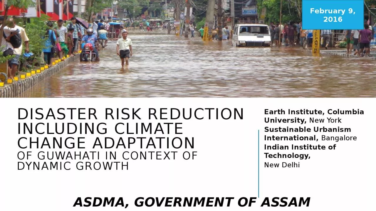
OF GUWAHATI IN CONTEXT OF DYNAMIC GROWTH Earth Institute Columbia University New York Sustainable Urbanism International Bangalore Indian Institute of Technology New Delhi February 9 2016 ID: 1045939

flood climate key water climate flood water key risk development drainage disaster management planning extremes hills amp building decision

Share:

Link:

Embed:

Download Presentation from below link

Download Presentation The PPT/PDF document "DISASTER RISK REDUCTION INCLUDING CLIMAT..." is the property of its rightful owner. Permission is granted to download and print the materials on this web site for personal, non-commercial use only, and to display it on your personal computer provided you do not modify the materials and that you retain all copyright notices contained in the materials. By downloading content from our website, you accept the terms of this agreement.


Presentation Transcript

1. DISASTER RISK REDUCTION INCLUDING CLIMATE CHANGE ADAPTATION OF GUWAHATI IN CONTEXT OF DYNAMIC GROWTHEarth Institute, Columbia University, New York Sustainable Urbanism International, BangaloreIndian Institute of Technology,New DelhiFebruary 9, 2016ASDMA, GOVERNMENT OF ASSAM

2. Project Recommendations (Key Areas)1. Urban Planning and Development2. Natural Resources - Hills and Water Bodies3. Data, Information and Decision Support4. Natural and Artificial Drainage5. Community and InstitutionsChanging Climate, Dynamic Growth hold the key to Guwahati flood risk

3. URBAN PLANNING AND DEVELOPMENT1

4. Mainstreaming Flood and Natural Disaster RiskIntegrating disaster risk reduction into comprehensive master plan and other city level plansFlood and landslide zoningSystematize evictions of encroachersPlan for increasing overall coping capacityConsistently enforce regulations- Set clear guidelines and time table, Standardize “no objection” certifications for hill cutting and for the “completion certification”, across all agencies. ‘Right Wrong Campaign’ – on Hill area development, for example. Increase low‐income housing and land allocation for residential uses in Comprehensive Masterplan: enhanced number of affordable housing for lower income families and Implement plan for three “New Towns” and for enhancing density of existing residential areas in new Master PlanUrban Planning & Development 1/5

5. Statutory MeasuresRules for Water bodies Conservation Act to be formulated and implementedRules for Hill and Forest Conservation Act to be formulated and implemented Flood risk areas and flood protections to be integrated into the recent Building Bye-lawsDevelopment control regulations incorporating resilient building designUrban Planning & Development 2/5

6. Infrastructure and ServicesRoads and TransportAssessing, rationalizing, and modifying all road levels to allow water to flow down. Road levels need to be matched to other road/drain levels and also to the levels of the houses in the area as many road levels are higher than the house levelIdentify roads and bridges that get frequently flooded and mark alternative routes and put boats in place to prevent traffic chaosEvacuation plans formulated with community participationDrainsCleaning, De-silting, Installing silt traps and providing drain coversIdentify and remove culverts and blockages on drains and streamsUrban Planning & Development 3/5

7. Infrastructure and Services (continued)Water supplyInvestigate potential flashpoints where sewage, flood water, and treated water get mixedAlternate water supply for flood prone areasSewage and Solid WasteBuild neighborhood solid waste collection areas on higher ground and garbage dumping ground outside city on higher ground with impervious bed to prevent contamination of ground waterComprehensive Solid Waste Management PlanPowerRe-locate main transformers on higher groundIn neighbourhoods that get frequently flooded, install solar power as back up for generatorsUrban Planning & Development 4/5

8. Short TermLong TermUrban Planning and DevelopmentFlood and landslide zoningSystematize evictions of encroachersRules for Water bodies Conservation Act and Hill and Forest Conservation Act need to be formulated and implemented Flood risk areas and flood protections need to be integrated into the recent Building Bye-lawsRelief, rescue and evacuation plan for the cityUrban Planning and DevelopmentIntegrating disaster risk reduction into comprehensive master plan and other city level plansIntegrating disaster risks into Land­‐use planning and large scale urban projectsIncrease low‐income housing and land allocation for residential uses Development control regulations incorporating resilient building designInfrastructureAssess disaster risks for key infrastructure and assets Neighbourhood level waste collection systemSystematic cleaning, desilting and repairs of drainsInfrastructureRoad Levels and Drainage DesignComprehensive Solid Waste Management PlanUrban Planning & Development 5/5Infrastructure and Services

9. NATURAL RESOURCES (HILLS AND WATER BODIES)2

10. Protection of Water BodiesPublic Consultations– ‘Campaign to stop Destruction of Guwahati’s Wetlands’Citizen Forums – ‘Monitoring Encroachment Champions’ Formalize Rules and Regulations for Existing ActsDevelop detailed maps of Deepor Beel, Silsako Beel, Bondjaan Beel, Borsola Beel and Sarusala BeelWetlands and Swamps - Integrated Watershed management, from the regional level downSystematize settlement and construction in eco­‐sensitive zones – ‘How to’ campaign materials on good practices: Terracing and Hill Cutting, Land and Road Development, Building on sloping landHills and Water bodies 1/3

11. Forests and HillsHills and ForestsClear definition and boundary marking of hills and forest landRemoval of unauthorized construction and encroachmentBuilding of channels to minimize erosionPlanting on hillsidesReforesting as necessary in forest areas on hillsReinforcement and securing of cut surfaces in hills Housing and Development on HillsRelocation of developments on hills as necessaryProvision of low-income housing in flood and mudslide safe areasBuilding retrofitting and design for disaster resilience (Landslide)Hills and Water bodies 2/3

12. Short TermLong TermWater BodiesCampaigns and Citizens ForaStudy development around water bodies and systematize settlement and construction in eco­‐sensitive zonesInclude communities through formal consultationsWater BodiesIntegrated Watershed managementPlans for protecting and revitalizing waterbodies in GMA Hills and ForestsClearly define and demarcate hill and forest landRemove of unauthorized construction and encroachmentReforesting as necessary in forest areas on hillsReinforcement and securing of cut surfaces in hills Hills and ForestsAppropriate hill slope conservation initiatives in identified areas to reduce levels of siltationBuilding retrofitting and design for disaster resilience (Landslide)Building retrofitting and design for disaster resilience (Landslide)Hills and Water bodies 3/3Hills and water Bodies

13. NATURAL AND ARTIFICIAL DRAINAGE3

14. Artificial DrainageIntegrated urban drainage and enhancing performance of existing drainage systemDevelop a “One Drain Map” for all of Guwahati’s major and secondary drains, and (over time) tertiary drains – to complement WRD’s ‘Comprehensive plan of natural drainage congestion’Identify system wide defects – regular backflows, geographically specific flooding reasonsIdentify critical systemic problems such as size of drains, rerouting of channels, re-levelling of secondary drains relative to primary drains, extensive reinforcing embankment wallsSubject key assumptions of system‐wide drainage to CC and population growth considerations – as input into major infrastructure plan & CMP – towards One Drain Action PlanSustainable drainage systems (SuDS) drainage solutions that provide an alternative to the direct channeling of surface water through networks of pipes and sewers to reduce pressure on existing drains especially in event if heavy rainfall – infiltration devices, vegetated surfaces, permeable paving, filter drains, infiltration basins, retention ponds..Natural & Artificial Drainage 1/3

15. Natural DrainageInstalling and cleaning filters and silt traps to drains and streams that pour into bigger streams, lakes, and rivers Removal of unauthorized development and encroachment in and around rivers, streams, and waterbodiesEstablishing and securing boundaries and edges. Security is in terms of reinforcement to keep from collapsing and also secured from encroachment and infillingCleaning and De-siltationRemoval of excessive plant growth in the lakes and pondsInstallation of visible water level monitors at regular distances in all rivers, streams, lakes, and pondsModification of rivers and Streams : Increase the flow area, Relief channelsFlood Defenses: Barrier embankments and flood wallsOne Drain Action PlanNatural & Artificial Drainage 2/3

16. Short TermLong TermArtificial DrainageOne Drain Map and One Drain Plan of ActionSystem‐wide drainage analysis based on CC and population growth Identify system wide defects and critical issuesArtificial DrainageIntegrated drainage planSustainable drainage systems Natural DrainageSecuring boundaries and edgesCleaning and De-siltationRemoval of unauthorized development and encroachment in and around rivers, streams, and waterbodiesNatural DrainageFlood Defenses: Barrier embankments and flood wallsModification of rivers and Streams : Increase the flow area, Relief channelsIntegrated Watershed ManagementNatural & Artificial Drainage 3/3Natural & Artificial Drainage

17. DATA, INFORMATION AND DECISIONS4

18. Data, Information and Decision Support: Systems are keyData management and decision support systems for collection, analysis and dissemination of critical information to key stakeholders to facilitate improved and informed decision makingFlood reporting system which will provide key insights into the disaster events and help in deciding short term and long term mitigation measuresUrban flood early warning system would extend flood reporting system to integrated long term forecasts and tools for interdepartmental coordination and implementation.Monitoring is recommended as part of the decision systems to understand and assess events and related efforts (long and short term) as a learning toolData to Decision Support 1/2

19. Short TermLong TermIdentify critical data requirements Develop reporting frameworkSystems and data infrastructureFlood Reporting SystemData Management and Decision Support SystemsFlood Early Warning SystemAudit and Monitoring FrameworkData to Decision Support 2/2Data, Information and Decision Support

20. COMMUNITY AND INSTITUTIOns5

21. Awareness and Capacity Building: ‘Community’ is keyDisaster risk communication at community levelAwareness building about linkages between solid waste, drains and floodingAwareness building about hills and siltationCitizen flood reporting systemInstitutional Capacity building for all key departments and agenciesCommunity driven initiativesCommunity level afforestation drivesCommunity Based Risk Assessment Community Based Relief, Rescue and RehabilitationCommunities and Institutions 1/3

22. InstitutionsUrban Flood Management cell/nodal committee: Institutional coordination and streamlining is critical. Recommend the establishment of an Urban Flood Management cell/nodal committee within the ASDMA with representatives from key departments and agencies as well as expert advisors, chaired by the Chief Secretary.This cell/nodal committee empowered to direct all activities pertaining to flood management and landslides in GMA.Standardize operating procedures regarding disaster risk prevention, relief and rescueCommunities and Institutions 2/3

23. Short TermLong TermDevelop citizen flood reporting system Develop communication material and preparedness guides for communitiesPeriodically (Pre-monsoon and post-monsoon) organize stakeholders meeting to review the events, measures and future ActionsCapacity building workshopUrban Flood Management cell/nodal committeeCommunity driven initiatives for afforestation drive, risk assessment relief, rescue and rehabilitationCommunities and Institutions 3/3Communities and Institutions

24. Project PARTNERSHIP effort

25. Close collaboration withAssam State Disaster Management AuthorityDistrict Disaster Management AuthorityForest DepartmentGuwahati Municipal CorporationGuwahati Metropolitan Development AuthorityKamrup Metro DC OfficePubic Works DepartmentRevenue DepartmentWater Resources Department& Anil Nagar, Nabin Nagar, Lachit Nagar, Ganesh Para and Dhiren Para Residents

26. Component1: Identification of key features of local climate and its projections for the GMAOutput 1.1: Historical climate data collection and analysis for the GMAIIT, DelhiIdentify and collect from IMD detailed information on daily weather from GMA weather stationDefine, identify and analyze historical weather characteristics and extremes Output 1.2: Climate forecast simulations and analysis for GMAIIT, DelhiValidate global and regional climate model simulations for the present dayDevelop 30-year time slice future projectionsProduce and store downscaled climate forecast simulation data on project serverExamine the characteristics of changes in climate extremes in the meteorological subdivision

27. Component 2: Mapping vulnerabilities to climate extremes, and assessing future risks based on past trendsOutput 2.1: Analysis of socioeconomic conditions and growth pattern of the GMASUI, BangaloreCollect relevant socioeconomic data of the GMAInvestigate patterns and drivers of historical development of the GMAOutput 2.2 Assessing risks and vulnerabilities to climate extremes of the GMACGSD, Earth Institute, New YorkReview of tools and methodology for assessing urban climate extremes risk vulnerabilityMap likely (climate extremes-related) flooding scenarios if current patterns of development continue (BAU) in the GMASUI, BangaloreResearch on key flooding events, impacts and reconstruction and rehabilitation efforts over the last 30 yearsMap the changing impacts of climate extreme risks on the iconic cultural heritage

28. Component 3: Mapping of key stakeholder institutions and their actions in the GMA, identifying key decisionsOutput 3.1: Field study of two neighborhoods in GMA to investigate climate risk management practicesSUI, BangaloreIdentify and select two contrasting neighborhoods in the GMA in which to perform a climate extremes risk field studyConduct field study (with research and stakeholder engagement) to investigate traditional spatial and cultural practices Output 3.2 Stakeholder and institutional landscape analysisSUI, BangaloreCatalogue and map key efforts to plan for and manage climate risks in the GMACGSD, Earth Institute, New YorkIdentify key gaps (e.g. necessary tools, resources, framing) in current planning efforts on adaptation to climate extremes in the GMAEngage stakeholders at different spatial levels within GMA to identify key decision pathways to enhance resiliency

29. Component 4: Adaptation solutions for climate extreme-related flooding in the GMAOutput 4.1: Tools to support suite of climate risk management solutionsSUI, Bangalore,CGSD, Earth Institute, New York,IIT, DelhiIdentify tools to enable spatial expression of risks from climate extremes across time scales to inform planning and designing climate risk adaptation solutions in the GMAOutput 4.2: Adaptation solutions for the GMA for climate extremes related floodingCGSD, Earth Institute, New York,Identify a suite of adaptation solutions for climate-extremes related flooding for the GMA, based on research and outputs from other project componentsSUI, Bangalore,CGSD, Earth Institute, New York,IIT, DelhiEngage key stakeholders in local government, the community and private sector, facilitated by relevant government agencies, to discuss, evaluate and improve upon the identified suite of solutionsFinalize suite of adaptation solutions for climate extremes related flooding for the GMA