Explore
Featured
Recent
Articles
Topics
Login
Upload
Featured
Recent
Articles
Topics
Login
Upload
Search Results for 'Lidar-Topographic'
Lidar-Topographic published presentations and documents on DocSlides.
Hydro Treatments of
by alida-meadow
Lidar-Derived DEMs. Stereo DTM. (Topographic Surf...
LiDAR Overview What LiDAR is . . .
by yoshiko-marsland
. . . . Li. ght . D. etection . A. nd . R. angin...
Reading Contour Maps (Including Topographic Maps):
by badra
Visualizing 3D Surfaces. Carol J. Ormand. , . SERC...
Introduction to Cut Slope Design & Topographic Surveying
by felicity
Yonathan Admassu, PhD. James Madison . University....
Topographic Maps TEKS 8.9 C
by natalia-silvester
interpret topographic maps and satellite views to...
Topographic Maps
by luanne-stotts
Aim: To be able to interpret a topographic Map.....
Topographic Map Skills
by jane-oiler
Topographic notes. Topographic Map-includes conto...
Topographic
by marina-yarberry
Maps. Topographic Map. :. A . contour map. -. Co...
topographic Map
by tatyana-admore
exit ticket. Topographic Map Exit Ticket. 1) What...
Topographic Maps
by briana-ranney
and . Compasses. Navigation Tools. Maps. Road map...
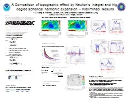
A Comparison of topographic effect by Newton’s integral a
by debby-jeon
YM . Wang, . S. . Holmes, J Saleh, XP Li . and D ...
Tiffany L. Caudle, Thomas A. Tremblay, Jeffrey G. Paine, Jo
by marina-yarberry
Bureau of Economic Geology. Jackson School of Geo...
LiDAR Enhanced Forest Inventory in British Columbia
by chaptoe
Challenges and Opportunities. By. Xiaoping Yuan. F...
Overview of upcoming lidar wake experiments at DTU
by clustik
Elliot Simon. DTU Wind Energy (. RISØ. ). ellsim@...
Characterizing CA Spotted Owl Habitat with Lidar
by verticalbikers
Jonathan Kane. Malcolm North. Van Kane. Greg Asner...
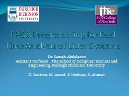
FPGA Programming for Real Time Analysis of Lidar
by lindy-dunigan
Systems. Dr. Sameh Abdelazim. Assistant Professor...
Community-wide urban stormwater planning utilizing LiDAR, the WinSLAMM model and GIS
by cheryl-pisano
Dan Murphy. Rebecca Gronewold. UNI GeoTREE Center...
Estimating Rooftop Solar Electricity Potential in Seattle from LiDAR Data
by pamella-moone
Ryan M. Liddell. Faculty advisor: Dr. Joe Bishop....
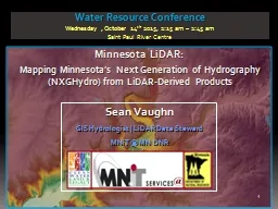
Minnesota LiDAR: Minnesota
by danika-pritchard
LiDAR. Wednesday , November 4. th . 2015, 1:00 pm...
AIMS use of Lidar Primary uses
by lois-ondreau
Contour creation. DTM/DSM generation. Ortho photo...
LiDAR Analysis of Mixed-Species, Multi-Cohort Stands
by tatyana-admore
Dr. John A. Kershaw, Jr.. Western . M. ensuration...
LiDAR Cave Mapper
by alexa-scheidler
FAMU-FSU College of Engineering. ME & ECE Sen...
Using LiDAR Data to Automatically Delineate Sinkholes in So
by natalia-silvester
Nate Green and Jacob Hartle. Forest and Natural R...
LiDAR Cave Mapper
by calandra-battersby
FAMU-FSU College of Engineering. ME & ECE Sen...
THE LIGHT FANTASTIC USING AIRBORNE LIDAR IN ARCHAEOLOGICAL SURVEY S
by cheryl-pisano
Crutchley Aerial Survey Investigation Research D...
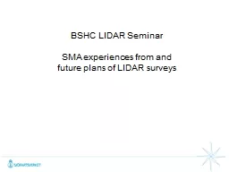
BSHC LIDAR
by faustina-dinatale
S. eminar. SMA . e. xperiences. . from and . fut...
LiDAR
by alexa-scheidler
Compressor 1.1. Compression. Lossless. 25. % or s...
High Accuracy Helicopter Lidar & Mapping
by natalia-silvester
Jeffrey B. Stroub, CP,RLS,PPS,SP. Vice President ...
Raster lidar data visualizations for
by tatiana-dople
interpretation. . of. . microrelief. . structu...
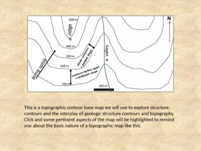
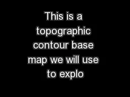
This is a topographic contour base map we will use to explore structure contours and the interplay
by natalie
a ridge. a valley. g. oing uphill. closer . cont...
SAINIK SCHOOL GOALPARA CHAPTER-4
by morgan
TOPIC-MAPS. GEOGRAPHY. CLASS-VI. WHAT ARE MAPS?. A...
Land Navigation Identify Topographic Symbols
by luanne-stotts
on a Military Map. Action: . Identify Topographi...
Architectural Design
by jane-oiler
Mapping Mechanics: . An introduction to topograp...
The study of the shapes and features of the Earth’s su
by alexa-scheidler
Topography. Shows the three dimensional shape ...
Effect of topographical resolution
by cheryl-pisano
on . cirrus clouds . using . a high-resolution . ...
Drawing Cross Sections of a Topographical Map
by kittie-lecroy
Specific Skill. What you need. Ruler. Pencil. Gri...
Topographic Mapping
by kittie-lecroy
Goals. Define and describe topographic maps.. Def...
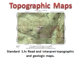
Standard 1.h: Read and interpret topographic and geologic m
by briana-ranney
Topographic Maps. Contouring. Topographic contour...
This is a topographic contour base map we will use to explo
by debby-jeon
a ridge. a valley. g. oing uphill. closer . con...
Office Hours
by tatyana-admore
Mon: 11:30 AM to 12:30 PM & 1:45 PM to 3:0...
Load More...