Explore
Featured
Recent
Articles
Topics
Login
Upload
Featured
Recent
Articles
Topics
Login
Upload
Search Results for 'Spatial-Data'
Spatial-Data published presentations and documents on DocSlides.
Geog 301: Lecture 4 The value of spatial data
by elina
Again, portions swiped from Dr. Sterling Quinn. Wh...
Preparing Spatial Data to Archive
by jocelyn
Yaxing . Wei. . &. Suresh K.S. . Vannan. Envi...
Organization Spatial Data Mining Fall 2011
by claire
Introduction. Region Discovery—Finding Interesti...
Locational Analytics, Spatial Decision-Making and Big Data:
by tatyana-admore
Overview . of Spatial Big Data and . Analytics. (...
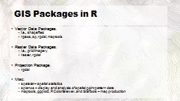
Spatial data in R
by sherrill-nordquist
M Sumner. Outline. Packages. Spatial. Import and ...
A CyberGIS Environment for Near-Real-Time Spatial
by shangmaxi
Analysis. . of . Social Media Data . Shaowen Wang...
Moving Toward Spatial Access: Lessons Learned
by conchita-marotz
Daniel Carter. UNC Highway Safety Research Center...
Introduction to Spatial Database System
by aaron
Presented by . Xiaozhi. Yu. Outline. What is spa...
Spatial Database Systems
by ellena-manuel
Tyler Reainthong. CSE 7330. Fall 2009. Topics. De...
Intro to Spatial Analysis with
by luanne-stotts
What can we do with GIS?. SPATIAL STATISTICS. Wha...
Regional marine spatial planning
by briana-ranney
- the Shetland experience. Rachel . Shucksmith. M...
Role of Spatial Database
by myesha-ticknor
in. Biodiversity Conservation Planning. Sham . Da...
What Spatial Thinking Skills are Important in Hydrogeology?
by freya
Peggy McNeal. 1. , Heather Petcovic. 2. , Joel Moo...
Estimating Mortality from Pneumoconiosis Using Multilevel Spatial Binary Regression
by playhomey
Rajib Paul, PhD. University of North Carolina at C...
Spatial Query Languages
by yoshiko-marsland
Standard Database Query Languages. Outline. What ...
Spatial Online Sampling and Aggregation
by liane-varnes
Robert Christensen. , Feifei Li. University of Ut...
Research Opportunities in Location Analytics, Spatial Decis
by lois-ondreau
Findings from . An AIS-based Survey. Namchul Shin...
Spatial Point Processes
by myesha-ticknor
Eric . Feigelson. Penn State University. Arcetri....
Reaction-diffusion equations with spatially distributed hys
by alexa-scheidler
Pavel. Gurevich, Sergey . Tikhomirov. Free Unive...
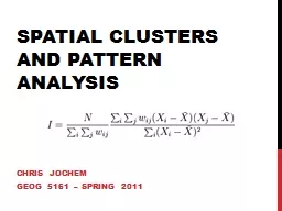
Spatial Clusters and Pattern Analysis
by pamella-moone
Chris Jochem. Geog. 5161 – Spring 2011. When y...
Inter-regional migration in Europe: a spatial interaction m
by lois-ondreau
Adam Dennett*, Kimberley . Claydon. †. , Pablo ...
Spatial Variability in Mortality and Socioeconomic Factors
by pasty-toler
Sixth International Longevity Risk and Capital Ma...
Investigation of Spatial Effects on Dopamine Reuptake Mechanism
by jones
Cihan. Kaya. 12/15/2015. Aims. Build and simulate...
EVALUATION OF A COMPLEMENTARY HEARING AID FOR SPATIAL SOUND
by kylie
SEGREGATION. Luca Giuliani. 1. , Luca . Brayda. 1....
Filtering Techniques and spatial filter types
by pamela
3. Filtering . Filtering image data. is a . stand...
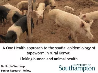
A One Health approach to the spatial epidemiology of tapeworm
by davies
in . rural Kenya: . Linking . human and animal . h...
Color Vision, Spatial Resolution, and Sex
by teresa
Daniel J. Chi. , . Alla. . Chavarga. , Taylan S. ...
Aquaculture Spatial Planning
by hadley
The case of Greece Nikos Anagnopoulos Panhellenic ...
Catherine C. Marshall, Frank M. Shipman III, James H. Coombs Spatial h
by patricia
Permission to copy without fee all or part of this...
Importance of Developing Spatial Skills for Success in CS
by broadcastworld
Laura Reasoner Jones. Well-developed spatial ski...
The Time-Varying Nature of Spatial Dependencies in Commercial Real Estate Prices:
by quorksha
A . Behavioral Explanation. Prashant Das, PhD. Ass...
Application of Spatial Statistics, Segmentation and Market Solutions to Examine Disparities in Hear
by cleverfan
Oral Presentation at The 143. rd. APHA Annual Mee...
The world around us: Nurturing spatial reasoning in rural schools
by luanne-stotts
Dr. Chris Reading. SiMERR. National Research Ce...
Supporting Spatial Thinking
by min-jolicoeur
: . Translating Research into Practice. ...
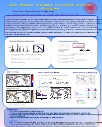
Spatial differences of burstiness in
by olivia-moreira
the temporal occurrence. of earthquakes. Xiaoxue ...
Segment 4 Building a Publication Record in GIS: The Spatial Research Ecosystem
by lois-ondreau
Presenter:. James Pick*, . University of . Redlan...
Topic 2 – Transportation and the Spatial Structure
by celsa-spraggs
Historical Geography of Transportation. Transport...
Visual-Spatial Learners What does it mean to be
by stefany-barnette
gifted in nonverbal reasoning?. Ability in spatia...
Cross-Border Maritime Spatial Plan for the Black Sea – Romania, Bulgaria
by stefany-barnette
MARSPLAN - BS . Steering Committee Meeting. 13. ...
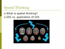
Spatial Thinking What is spatial thinking?
by tatyana-admore
GIS vs. application of GIS. Spatial Thinking. “...
Load More...