Explore
Featured
Recent
Articles
Topics
Login
Upload
Featured
Recent
Articles
Topics
Login
Upload
Search Results for ''
published presentations and documents on DocSlides.
Flood damage models – Scope and limitations
by jordyn
Forest Resources and Climate Unit. Institute for E...
NASA Flood Response Workshop
by anastasia
Presentation template. NGA Talking Points. What is...
Publishing and Accessing Services using ArcGIS for Flood An
by test
Harish Sangireddy. The University of Texas at Aus...
Using topography to estimate flood risk
by trish-goza
Brendan Murphy. CE 397 Flood Forecasting. May 4, ...
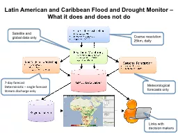
Latin American and Caribbean Flood and Drought Monitor –
by lindy-dunigan
What it does and does not do. Figure showing curr...
WV Flood Risk Mapping Status and
by kittie-lecroy
Needs. Lee Brancheau, GISP. FEMA Region III, Risk...
Reported Flood Inundation due to Hurricane Harvey in Houston, TX
by alexa-scheidler
Isha Deo. November 21, 2017. Specific Issues duri...
Update on Use of Hazus for FEMA Risk MAP Flood Risk Products
by alida-meadow
Shane Parson . – RAMPP . PTS (. URS). Agenda. O...
Using HAZUS for the Flood Risk Assessment Dataset within FEMA Risk MAP Studies
by yoshiko-marsland
Dr. Shane Parson, PE, CFM, URS (RAMPP Team). 201...
Patterns of Historic River Flood Events in the Mid-Atlantic Region
by debby-jeon
Richard H. Grumm. NOAA/NWS Weather Forecast Offic...
Flood risk analysis in the Kosi river basin north Bihar using multip
by jade
three tributaries within the Himalaya, the Sun-Kos...
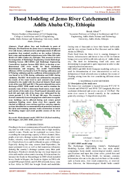
Flood Modeling
by violet
of Jemo River Catchement in Addis Ababa City Ethio...
CE 397 Flood Forecasting
by phoebe-click
Lecture 3: Review of Concepts and Definitions. Na...
National Weather Service Flash Flood Program
by min-jolicoeur
Overview. By Hector Guerrero. Warning and Coordi...
Flood Predictions in Smithfield and Birch Creek Canyons res
by luanne-stotts
GIS in Water Resources Presentation. By: . Zac. ...
CE 397 Flood Forecasting
by aaron
Lecture 3: Review of Concepts and Definitions. Na...
ARISTOTLE: Flood hazard summary
by sherrill-nordquist
Milano. Bo Holst, Fredrik Linde, Richard Wylde. J...
Flood Zones in Wake County
by tawny-fly
Georgia . Ditmore. University of North Carolina a...
National Weather Service Flash Flood Program
by liane-varnes
Overview. By Hector Guerrero. Warning and Coordi...
Hurricane Harvey: Flood Emergency Response
by kittie-lecroy
Hurricane Harvey . Flood forecasting. Texas Flood...
Flood Routing By Reservoir
by pasty-toler
Flood Routing By Reservoir Prafulla Po...
HEZA A GISbased Method for Improved Approximate Flood Risk Analyses
by jordyn
2 Introduction The National Flood Insurance Progr...
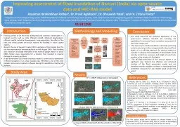
Improving assessment of flood Inundation of Navsari (India) via Open-source data and HEC-RAS model
by thomas
Azazkhan Ibrahimkhan Pathan. 1. , Dr. Prasit Agni...
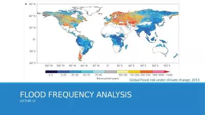
FLOOD FREQUENCY ANALYSIS
by catherine
LECTURE 13. Global Flood risk under climate change...
Data Science and Emergency Preparedness at CCICADA
by RainbowGlow
Fred Roberts. Director, CCICADA. DHS . CVADA Cente...
Agencies’ response to DRM pilot EO data requirements
by phoebe-click
Ivan . Petiteville. (ESA, Chair . WGDisasters. )...
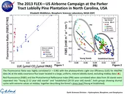
The Fluorescence Ratio was highly correlated (r = 0.96) with the photosynthetic Light Use Efficiency (LUE) for AM/PM data (
by calandra-battersby
The Fluorescence Ratio was highly correlated (r =...
Uncertainty in the modelling of large scale flood events in the
by accouther
Barotse. floodplain, Zambia. . Tom Willis. 1. , ...
Mat Mampara, PE, CFM – Dewberry
by olivia-moreira
Victor Hom, National Weather Service. Stuart Geig...
Marie C. Peppler
by faustina-dinatale
USGS FIM Program Liaison. Flood . Inundation . Ma...
Flooding in San Salvador
by cheryl-pisano
Carlos Felipe Gutierrez. Fall 2010. Outline. The ...
Marie C. Peppler USGS FIM
by liane-varnes
Coordinator. Flood . Inundation . Mapping. Progra...
Overview of FEMA’s Risk MAP Program &
by giovanna-bartolotta
Taming the Terrain Beast. Arc Hydro River Worksho...
Mat Mampara, PE, CFM – Dewberry
by lindy-dunigan
Victor Hom, National Weather Service. Stuart Geig...
flood Modelling of Kalu-Ganga river basin
by provingintel
H. K. . Nandalal. Department of Civil Engineering....
Hardware, Software, and Protocols for the next generation of Environmental Monitoring Networks
by clustik
Johns Hopkins University Department of Computer Sc...
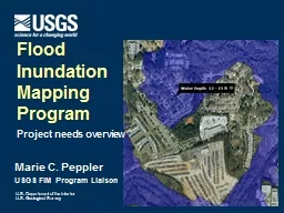
Marie C. Peppler USGS FIM Program Liaison
by mentegor
Flood . Inundation . Mapping. Program. Project nee...
Lesson Eight: Reports and Documentation
by luanne-stotts
OBJECTIVE: Evaluate the actions taken during a ri...
Regional Flood Plain Management Council
by myesha-ticknor
April 15, 2015. H-GAC. December 2nd. . Purpose....
by friendma
Christoph F. . Eick. ...
Load More...